इश्कोमन इन्हें भी देखें सन्दर्भ दिक्चालन सूचीیارانِ محفل کے ساتھ ایک دن اشکومن میں (यारान-ए-महफ़िल के साथ एक दिन इश्कोमन में)Pakistan and the Karakoram Highway
ग़िज़र ज़िलागिलगित-बल्तिस्तानपाक-अधिकृत कश्मीरगिलगित-बल्तिस्तान की घाटियाँ
पाक-अधिकृत कश्मीरगिलगित-बलतिस्तानग़िज़र ज़िलेतहसीलहिन्दु कुशहिन्दु राजकाराकोरमगिलगित
इश्कोमन اشکومن / Ishkoman | |
|---|---|
 | |
| सूचना | |
राजधानी : | ? |
क्षेत्रफल : | ? किमी² |
जनसंख्या(-): • घनत्व : | ३०,००० ?/किमी² |
| उपविभागों के नाम: | गाँव |
| उपविभागों की संख्या: | २० |
| मुख्य भाषा(एँ): | खोवार, शीना, बुरूशसकी, वाख़ी |
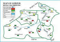
इश्कोमन या इश्कुमन (اشکومن, Ishkoman) पाक-अधिकृत कश्मीर के गिलगित-बलतिस्तान क्षेत्र के ग़िज़र ज़िले की एक घाटी है। प्रशासनिक दृष्टि से यह ग़िज़र ज़िले की एक तहसील है।[1] इस तहसील की ऊँचाई ७,००० से १२,००० फ़ुट (२,१०० से ३,७०० मीटर) के बीच है और यह हिन्दु कुश पर्वतों की हिन्दु राज शाखा और काराकोरम पर्वतों के मिलन क्षेत्र में गिलगित से १४० किमी दूर स्थित है।[2]
इन्हें भी देखें
- यासीन वादी
- ग़िज़र ज़िला
सन्दर्भ
↑ یارانِ محفل کے ساتھ ایک دن اشکومن میں (यारान-ए-महफ़िल के साथ एक दिन इश्कोमन में), Amir Jan Haqqani, 11 मार्च 2012, Pamir Times, ... اشکومن گلگت بلتستان کے ضلع غذر میں واقع ایک حسین وادی ہے۔ انتظامی طور پر اشکومن ایک تحصیل ہے (इश्कोमन गिलगित बलतिस्तान के ज़िले ग़िज़र में वाक़े एक हसीन वादी है। इन्तज़ामी तौर पर इश्कोमन एक तहसील है) ...
↑ Pakistan and the Karakoram Highway, Lindsay Brown, Paul Clammer, Rodney Cocks, John Mock, pp. 282, Lonely Planet, 2008, ISBN 9781741045420, ... The mountains are the Hindu Raj, an arm of the Hindukush (to geographers, the Karakoram Range only begins east of Ishkoman) ...
-ग़िज़र ज़िला, गिलगित-बल्तिस्तान, गिलगित-बल्तिस्तान की घाटियाँ, पाक-अधिकृत कश्मीर


