King's Newnham Contents History Today Notes Source and external links Navigation menuIn 2001 census subsumed into Church Lawford by postcode searchSP45277152°23′28″N 1°20′10″W / 52.391°N 1.336°W / 52.391; -1.33652°23′28″N 1°20′10″W / 52.391°N 1.336°W / 52.391; -1.336"King's Newnham Tower"the original"Details from listed building database (1029535)""Details from listed building database (1034906)""Details from listed building database (1034907)""Details from listed building database (1185475)""Details from listed building database (1185478)""Details from listed building database (1365092)"Its page in The Birmingham and Midland Society for Genealogy and Heraldry's websiteContact details for its Parish MeetingMap sources
Villages in Warwickshire
civil parishRugbyCoventryChurch LawfordRugbyWarwickshireenclosuresManorparishChurch LawfordWarwickshire AvonChurch Lawford
| King's Newnham | |
|---|---|
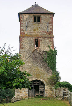 Tower of Church of St Laurence | |
 King's Newnham Location within Warwickshire | |
| Population | 50 In 2001 census subsumed into Church Lawford by postcode search |
| OS grid reference | SP452771 |
| District |
|
| Shire county |
|
| Region |
|
| Country | England |
| Sovereign state | United Kingdom |
| Post town | COVENTRY |
| Postcode district | CV23 |
| Dialling code | 024 |
| Police | Warwickshire |
| Fire | Warwickshire |
| Ambulance | West Midlands |
| EU Parliament | West Midlands |
| UK Parliament |
|
King's Newnham (otherwise known as Newnham Regis) is a village and civil parish located just under 2.5 miles (4 km) west of the town of Rugby and 4.5 miles (7 km) east of Coventry. For population details see Church Lawford. It is within the borough of Rugby and Warwickshire county council.
Contents
1 History
2 Today
3 Notes
4 Source and external links
History
The village lost most of its population as a result of enclosures of the former Royal Manor. Its parish church, St Laurence's, was built in the 12th century and partially demolished 1795–97. This left the mostly 16th-century tower and the church disused.[1][2]
The five other listed buildings of the parish are very close relative to the distant northern parish border: Farm Building near Newnham Hall, The Laurels, Highfield House, Newnham Hall and Manor Farmhouse.[3][4][5][6][7]
Today
For ecclesiastical purposes King's Newnham is joined with nearby Church Lawford from which it is separated by the Warwickshire Avon to the south. The parish council meets and shares the community facilities of Church Lawford community hall.
Notes
^ "King's Newnham Tower". Church Lawford and King's Newnham online. Archived from the original on 2006-06-01..mw-parser-output cite.citationfont-style:inherit.mw-parser-output .citation qquotes:"""""""'""'".mw-parser-output .citation .cs1-lock-free abackground:url("//upload.wikimedia.org/wikipedia/commons/thumb/6/65/Lock-green.svg/9px-Lock-green.svg.png")no-repeat;background-position:right .1em center.mw-parser-output .citation .cs1-lock-limited a,.mw-parser-output .citation .cs1-lock-registration abackground:url("//upload.wikimedia.org/wikipedia/commons/thumb/d/d6/Lock-gray-alt-2.svg/9px-Lock-gray-alt-2.svg.png")no-repeat;background-position:right .1em center.mw-parser-output .citation .cs1-lock-subscription abackground:url("//upload.wikimedia.org/wikipedia/commons/thumb/a/aa/Lock-red-alt-2.svg/9px-Lock-red-alt-2.svg.png")no-repeat;background-position:right .1em center.mw-parser-output .cs1-subscription,.mw-parser-output .cs1-registrationcolor:#555.mw-parser-output .cs1-subscription span,.mw-parser-output .cs1-registration spanborder-bottom:1px dotted;cursor:help.mw-parser-output .cs1-ws-icon abackground:url("//upload.wikimedia.org/wikipedia/commons/thumb/4/4c/Wikisource-logo.svg/12px-Wikisource-logo.svg.png")no-repeat;background-position:right .1em center.mw-parser-output code.cs1-codecolor:inherit;background:inherit;border:inherit;padding:inherit.mw-parser-output .cs1-hidden-errordisplay:none;font-size:100%.mw-parser-output .cs1-visible-errorfont-size:100%.mw-parser-output .cs1-maintdisplay:none;color:#33aa33;margin-left:0.3em.mw-parser-output .cs1-subscription,.mw-parser-output .cs1-registration,.mw-parser-output .cs1-formatfont-size:95%.mw-parser-output .cs1-kern-left,.mw-parser-output .cs1-kern-wl-leftpadding-left:0.2em.mw-parser-output .cs1-kern-right,.mw-parser-output .cs1-kern-wl-rightpadding-right:0.2em
^ Historic England. "Details from listed building database (1029535)". National Heritage List for England. Retrieved 21 May 2012.
^ Historic England. "Details from listed building database (1034906)". National Heritage List for England. Retrieved 21 May 2012.
^ Historic England. "Details from listed building database (1034907)". National Heritage List for England. Retrieved 21 May 2012.
^ Historic England. "Details from listed building database (1185475)". National Heritage List for England. Retrieved 21 May 2012.
^ Historic England. "Details from listed building database (1185478)". National Heritage List for England. Retrieved 21 May 2012.
^ Historic England. "Details from listed building database (1365092)". National Heritage List for England. Retrieved 21 May 2012.
Source and external links
| Wikimedia Commons has media related to King's Newnham. |
- Its page in The Birmingham and Midland Society for Genealogy and Heraldry's website
- Contact details for its Parish Meeting
Map sources for King's Newnham
Nearest Settlements | ||||||||||
|---|---|---|---|---|---|---|---|---|---|---|
| ||||||||||
Villages in WarwickshireUncategorized


