Mount Ida Cities Service Filling Station See also References Navigation menu34°33′23″N 93°38′1″W / 34.55639°N 93.63361°W / 34.55639; -93.6336134°33′23″N 93°38′1″W / 34.55639°N 93.63361°W / 34.55639; -93.63361Arkansas Highway History and Architecture MPS01001230"National Register Information System"http://www.arkansaspreservation.com/National-Register-Listings/PDF/MN0045.nr.pdfeexpanding ite
Gas stations on the National Register of Historic Places in ArkansasCommercial buildings completed in 1925Buildings and structures in Montgomery County, ArkansasNational Register of Historic Places in Montgomery County, ArkansasSouthwest Arkansas Registered Historic Place stubs
Mount Ida, ArkansasNational Register of Historic Places
Mount Ida Cities Service Filling Station | |
U.S. National Register of Historic Places | |
 | |
 Show map of Arkansas  Show map of the United States | |
| Location | 204 Whittington, Mount Ida, Arkansas |
|---|---|
| Coordinates | 34°33′23″N 93°38′1″W / 34.55639°N 93.63361°W / 34.55639; -93.63361Coordinates: 34°33′23″N 93°38′1″W / 34.55639°N 93.63361°W / 34.55639; -93.63361 |
| Area | less than one acre |
| Built | 1925 (1925) |
| Architectural style | Bungalow/craftsman |
| MPS | Arkansas Highway History and Architecture MPS |
| NRHP reference # | 01001230[1] |
| Added to NRHP | November 19, 2001 |
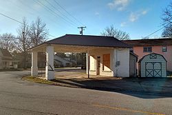
The Mount Ida Cities Service Filling Station is a historic automotive service station at 204 Whittington Street in Mount Ida, Arkansas. It is a small five-sided frame structure, finished in brick that has been stucoed over, with a hip roof that extends to form a canopy over the service area, with supporting brick piers at the far corners. Its front (under the canopy) has fixed four-pane windows flanking a center entrance. Built in 1925, it was used as a gas station until 1966, and has since housed a variety of small businesses. Its role as a gas station was briefly resurrected in the film White River Kid, which was shot here in 1998.[2]
The building was listed on the National Register of Historic Places in 2001.[1]
See also
- National Register of Historic Places listings in Montgomery County, Arkansas
References
^ ab National Park Service (2010-07-09). "National Register Information System". National Register of Historic Places. National Park Service..mw-parser-output cite.citationfont-style:inherit.mw-parser-output .citation qquotes:"""""""'""'".mw-parser-output .citation .cs1-lock-free abackground:url("//upload.wikimedia.org/wikipedia/commons/thumb/6/65/Lock-green.svg/9px-Lock-green.svg.png")no-repeat;background-position:right .1em center.mw-parser-output .citation .cs1-lock-limited a,.mw-parser-output .citation .cs1-lock-registration abackground:url("//upload.wikimedia.org/wikipedia/commons/thumb/d/d6/Lock-gray-alt-2.svg/9px-Lock-gray-alt-2.svg.png")no-repeat;background-position:right .1em center.mw-parser-output .citation .cs1-lock-subscription abackground:url("//upload.wikimedia.org/wikipedia/commons/thumb/a/aa/Lock-red-alt-2.svg/9px-Lock-red-alt-2.svg.png")no-repeat;background-position:right .1em center.mw-parser-output .cs1-subscription,.mw-parser-output .cs1-registrationcolor:#555.mw-parser-output .cs1-subscription span,.mw-parser-output .cs1-registration spanborder-bottom:1px dotted;cursor:help.mw-parser-output .cs1-ws-icon abackground:url("//upload.wikimedia.org/wikipedia/commons/thumb/4/4c/Wikisource-logo.svg/12px-Wikisource-logo.svg.png")no-repeat;background-position:right .1em center.mw-parser-output code.cs1-codecolor:inherit;background:inherit;border:inherit;padding:inherit.mw-parser-output .cs1-hidden-errordisplay:none;font-size:100%.mw-parser-output .cs1-visible-errorfont-size:100%.mw-parser-output .cs1-maintdisplay:none;color:#33aa33;margin-left:0.3em.mw-parser-output .cs1-subscription,.mw-parser-output .cs1-registration,.mw-parser-output .cs1-formatfont-size:95%.mw-parser-output .cs1-kern-left,.mw-parser-output .cs1-kern-wl-leftpadding-left:0.2em.mw-parser-output .cs1-kern-right,.mw-parser-output .cs1-kern-wl-rightpadding-right:0.2em
^ (PDF). Arkansas Preservation http://www.arkansaspreservation.com/National-Register-Listings/PDF/MN0045.nr.pdf. Retrieved 2015-10-12. Missing or empty|title=(help)
U.S. National Register of Historic Places | |
|---|---|
| Topics |
|
| Lists by state |
|
| Lists by insular areas |
|
| Lists by associated state |
|
| Other areas |
|
| |
This article about a property in Montgomery County, Arkansas on the National Register of Historic Places is a stub. You can help Wikipedia by expanding it. |
Arkansas, Buildings and structures in Montgomery County, Commercial buildings completed in 1925, Gas stations on the National Register of Historic Places in Arkansas, National Register of Historic Places in Montgomery County, Southwest Arkansas Registered Historic Place stubsUncategorized


