List of Indiana state historical markers in Washington County Historical markers See also References External links Navigation menuOpenStreetMapKMLGPX38°36′20″N 86°6′3″W / 38.60556°N 86.10083°W / 38.60556; -86.10083 (Morgan's Raid July 8-13, 1863)38°37′10″N 86°6′2″W / 38.61944°N 86.10056°W / 38.61944; -86.10056 (Brock Cemetery)38°43′25″N 86°5′28″W / 38.72361°N 86.09111°W / 38.72361; -86.09111 (Illinoian Glacier Boundary)38°36′21″N 86°6′3″W / 38.60583°N 86.10083°W / 38.60583; -86.10083 (Washington County Courthouse/Salem Downtown Historic District)38°30′58″N 86°0′4″W / 38.51611°N 86.00111°W / 38.51611; -86.00111 (Skirmish Near Pekin)"Indiana Historical Markers by County"Morgan's Raid July 8-13, 1863Brock CemeteryIllinoian Glacier BoundaryWashington County Courthouse/Salem Downtown Historic DistrictSkirmish Near PekinIndiana Historical Marker ProgramIndiana Historical Bureaue
SalemBrownFranklinGibsonHowardJacksonJeffersonMadisonMonroePiercePolkPoseyVernonWashingtonBartleBecks MillBlue RiverBrimstone CornersBunker HillCantonClaysvilleDaisy HillFair AcresFairviewFarabeeFayettevilleGeorgetownGooseportHaleysburyHarristownHighlandHitchcockKossuthMartin HeightsMartinsburgMcCol PlaceMcKinleyMillportMount CarmelNew LibertyNew PhiladelphiaNew SalemOld PekinOrgan SpringsPlattsburgProwsvillePumpkin CenterRosebudRush Creek ValleyShorts CornerSmedleySouth Boston
Indiana state historical markersTourist attractions in Washington County, IndianaLouisville metropolitan area-related lists
Washington CountyIndianaUnited StatesIndiana Historical Bureau

Location of Washington County in Indiana
This is a list of the Indiana state historical markers in Washington County.
This is intended to be a complete list of the official state historical markers placed in Washington County, Indiana, United States by the Indiana Historical Bureau. The locations of the historical markers and their latitude and longitude coordinates are included below when available, along with their names, years of placement, and topics as recorded by the Historical Bureau. There are 5 historical markers located in Washington County.[1]
Historical markers
| Marker title | Image | Year placed | Location | Topics |
|---|---|---|---|---|
Morgan's Raid July 8-13, 1863[2] |  | 1963 | Southern side of the Washington County Courthouse in Salem 38°36′20″N 86°6′3″W / 38.60556°N 86.10083°W / 38.60556; -86.10083 (Morgan's Raid July 8-13, 1863) | Military |
Brock Cemetery[3] | 1981 | State Road 135 on the southwestern corner of the Brock Creek bridge, 0.5 miles north of Salem 38°37′10″N 86°6′2″W / 38.61944°N 86.10056°W / 38.61944; -86.10056 (Brock Cemetery) | Cemetery, Early Settlement and Exploration | |
Illinoian Glacier Boundary[4] | 1995 | Northeastern corner of the junction of State Road 135 and Lick Skillet Road, 8 miles north of Salem 38°43′25″N 86°5′28″W / 38.72361°N 86.09111°W / 38.72361; -86.09111 (Illinoian Glacier Boundary) | Nature and Natural Disasters | |
Washington County Courthouse/Salem Downtown Historic District[5] | 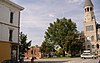 | 1998 | Northern side of the Washington County Courthouse in Salem 38°36′21″N 86°6′3″W / 38.60583°N 86.10083°W / 38.60583; -86.10083 (Washington County Courthouse/Salem Downtown Historic District) | Historic District, Neighborhoods, and Towns, Buildings and Architecture, Government Institutions |
Skirmish Near Pekin[6] | 2005 | Near 5751 E. Greenbriar Road West, near Pekin 38°30′58″N 86°0′4″W / 38.51611°N 86.00111°W / 38.51611; -86.00111 (Skirmish Near Pekin) | Military |
See also
- List of Indiana state historical markers
- National Register of Historic Places listings in Washington County, Indiana
References
^ "Indiana Historical Markers by County". State of Indiana. Retrieved 2012-03-15..mw-parser-output cite.citationfont-style:inherit.mw-parser-output .citation qquotes:"""""""'""'".mw-parser-output .citation .cs1-lock-free abackground:url("//upload.wikimedia.org/wikipedia/commons/thumb/6/65/Lock-green.svg/9px-Lock-green.svg.png")no-repeat;background-position:right .1em center.mw-parser-output .citation .cs1-lock-limited a,.mw-parser-output .citation .cs1-lock-registration abackground:url("//upload.wikimedia.org/wikipedia/commons/thumb/d/d6/Lock-gray-alt-2.svg/9px-Lock-gray-alt-2.svg.png")no-repeat;background-position:right .1em center.mw-parser-output .citation .cs1-lock-subscription abackground:url("//upload.wikimedia.org/wikipedia/commons/thumb/a/aa/Lock-red-alt-2.svg/9px-Lock-red-alt-2.svg.png")no-repeat;background-position:right .1em center.mw-parser-output .cs1-subscription,.mw-parser-output .cs1-registrationcolor:#555.mw-parser-output .cs1-subscription span,.mw-parser-output .cs1-registration spanborder-bottom:1px dotted;cursor:help.mw-parser-output .cs1-ws-icon abackground:url("//upload.wikimedia.org/wikipedia/commons/thumb/4/4c/Wikisource-logo.svg/12px-Wikisource-logo.svg.png")no-repeat;background-position:right .1em center.mw-parser-output code.cs1-codecolor:inherit;background:inherit;border:inherit;padding:inherit.mw-parser-output .cs1-hidden-errordisplay:none;font-size:100%.mw-parser-output .cs1-visible-errorfont-size:100%.mw-parser-output .cs1-maintdisplay:none;color:#33aa33;margin-left:0.3em.mw-parser-output .cs1-subscription,.mw-parser-output .cs1-registration,.mw-parser-output .cs1-formatfont-size:95%.mw-parser-output .cs1-kern-left,.mw-parser-output .cs1-kern-wl-leftpadding-left:0.2em.mw-parser-output .cs1-kern-right,.mw-parser-output .cs1-kern-wl-rightpadding-right:0.2em
^ Morgan's Raid July 8-13, 1863, Indiana Historical Bureau, n.d. Accessed 2012-03-14.
^ Brock Cemetery, Indiana Historical Bureau, n.d. Accessed 2012-03-14.
^ Illinoian Glacier Boundary, Indiana Historical Bureau, n.d. Accessed 2012-03-14.
^ Washington County Courthouse/Salem Downtown Historic District, Indiana Historical Bureau, n.d. Accessed 2012-03-14.
^ Skirmish Near Pekin, Indiana Historical Bureau, n.d. Accessed 2012-03-14.
External links
- Indiana Historical Marker Program
- Indiana Historical Bureau
Municipalities and communities of Washington County, Indiana, United States | ||
|---|---|---|
County seat: Salem | ||
| City |
| |
| Towns |
| |
| Townships |
| |
| CDP |
| |
| Unincorporated communities |
| |
Indiana, Indiana state historical markers, Louisville metropolitan area-related lists, Tourist attractions in Washington CountyUncategorized


