Brooklyn, Pretoria History Demographics References Navigation menu25°46′12″S 28°14′12″E / 25.770117°S 28.236570°E / -25.770117; 28.23657025°46′12″S 28°14′12″E / 25.770117°S 28.236570°E / -25.770117; 28.236570"Sub Place Brooklyn"eexpanding ite
Suburbs of PretoriaGauteng geography stubs
suburbPretoriaSouth AfricaUniversity of PretoriaGroenkloofWaterkloofPretoria Boys High SchoolBrooklyn MallSouth African National Census of 2011WhiteBlack AfricanIndian or AsianColouredAfrikaansEnglishNorthern SothoTswanaVan Wouw MuseumUniversity of Pretoria
Brooklyn | |
|---|---|
 Nieuw Muckleneuk and Brooklyn suburbs | |
 Brooklyn Show map of Gauteng  Brooklyn Show map of South Africa | |
| Coordinates: 25°46′12″S 28°14′12″E / 25.770117°S 28.236570°E / -25.770117; 28.236570Coordinates: 25°46′12″S 28°14′12″E / 25.770117°S 28.236570°E / -25.770117; 28.236570 | |
| Country | South Africa |
| Province | Gauteng |
| Municipality | City of Tshwane |
| Main Place | Pretoria |
| Established | 1902 |
| Area [1] | |
| • Total | 2.56 km2 (0.99 sq mi) |
| Population (2011)[1] | |
| • Total | 4,177 |
| • Density | 1,600/km2 (4,200/sq mi) |
| Racial makeup (2011) [1] | |
| • Black African | 18.8% |
| • Coloured | 1.6% |
| • Indian/Asian | 2.2% |
| • White | 74.8% |
| • Other | 2.6% |
First languages (2011) [1] | |
| • Afrikaans | 51.3% |
| • English | 33.8% |
| • Northern Sotho | 2.4% |
| • Tswana | 1.9% |
| • Other | 10.6% |
| Time zone | UTC+2 (SAST) |
Postal code (street) | 0181 |
| PO box | 0011 |
Brooklyn is a suburb of the city of Pretoria, South Africa. It is a well-established area, lying to the east of the city centre, encompassing high-end residential properties and several upmarket mall developments. It borders the University of Pretoria to its north and the suburbs of Groenkloof and Waterkloof to its south. Brooklyn is also the location of Pretoria Boys High School. The Brooklyn Mall opened in 1989.
History
The suburb was established on an old farm called Uitval in 1902 and takes its name from the surveyor James Brook.[2]
Demographics
According to the South African National Census of 2011, 4,177 people lived in Brooklyn.
74.8% were White, 18.8% Black African, 2.2% Indian or Asian and 1.6% Coloured.
51.3% spoke Afrikaans, 33.8% English, 2.4% Northern Sotho, 1.9% Tswana and 10.6% some other language as their first language.
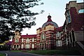
Main building of Pretoria Boys High School

Anton van Wouw House, housing the Van Wouw Museum of the University of Pretoria

Brooks House was built shortly after James Brooks purchased the land that would form part of Brooklyn, Pretoria in 1886. James Brooks was partially responsible for the layout of the Brooklyn township.


References
^ abcd "Sub Place Brooklyn". Census 2011..mw-parser-output cite.citationfont-style:inherit.mw-parser-output .citation qquotes:"""""""'""'".mw-parser-output .citation .cs1-lock-free abackground:url("//upload.wikimedia.org/wikipedia/commons/thumb/6/65/Lock-green.svg/9px-Lock-green.svg.png")no-repeat;background-position:right .1em center.mw-parser-output .citation .cs1-lock-limited a,.mw-parser-output .citation .cs1-lock-registration abackground:url("//upload.wikimedia.org/wikipedia/commons/thumb/d/d6/Lock-gray-alt-2.svg/9px-Lock-gray-alt-2.svg.png")no-repeat;background-position:right .1em center.mw-parser-output .citation .cs1-lock-subscription abackground:url("//upload.wikimedia.org/wikipedia/commons/thumb/a/aa/Lock-red-alt-2.svg/9px-Lock-red-alt-2.svg.png")no-repeat;background-position:right .1em center.mw-parser-output .cs1-subscription,.mw-parser-output .cs1-registrationcolor:#555.mw-parser-output .cs1-subscription span,.mw-parser-output .cs1-registration spanborder-bottom:1px dotted;cursor:help.mw-parser-output .cs1-ws-icon abackground:url("//upload.wikimedia.org/wikipedia/commons/thumb/4/4c/Wikisource-logo.svg/12px-Wikisource-logo.svg.png")no-repeat;background-position:right .1em center.mw-parser-output code.cs1-codecolor:inherit;background:inherit;border:inherit;padding:inherit.mw-parser-output .cs1-hidden-errordisplay:none;font-size:100%.mw-parser-output .cs1-visible-errorfont-size:100%.mw-parser-output .cs1-maintdisplay:none;color:#33aa33;margin-left:0.3em.mw-parser-output .cs1-subscription,.mw-parser-output .cs1-registration,.mw-parser-output .cs1-formatfont-size:95%.mw-parser-output .cs1-kern-left,.mw-parser-output .cs1-kern-wl-leftpadding-left:0.2em.mw-parser-output .cs1-kern-right,.mw-parser-output .cs1-kern-wl-rightpadding-right:0.2em
^ Raper, Peter E.; Moller, Lucie A.; du Plessis, Theodorus L. (2014). Dictionary of Southern African Place Names. Jonathan Ball Publishers. p. 1412. ISBN 9781868425501.
Communities of City of Tshwane Metropolitan Municipality, Gauteng | ||
|---|---|---|
Seat: Pretoria | ||
| Cities and towns |
|  |
| Suburbs of Centurion |
| |
| Suburbs of Pretoria |
| |
This Gauteng location article is a stub. You can help Wikipedia by expanding it. |
Gauteng geography stubs, Suburbs of PretoriaUncategorized


