Grade II* listed buildings in Redcar and Cleveland Redcar and Cleveland Notes External links Navigation menuOpenStreetMapKMLGPXNZ616501611854°32′12″N 1°02′55″W / 54.536588°N 1.048721°W / 54.536588; -1.048721 (Church of St Nicholas)1329545NZ569241325554°30′41″N 1°07′20″W / 54.511414°N 1.122303°W / 54.511414; -1.122303 (Church of St Oswald)1139807NZ595291436854°31′16″N 1°04′55″W / 54.521117°N 1.081849°W / 54.521117; -1.081849 (Estate Office, Former Joiner's Workshop to West of Home Farmhouse)1271502NZ637121936754°33′56″N 1°00′58″W / 54.565528°N 1.016156°W / 54.565528; -1.016156 (Old Church of St Andrew)1139759NZ595931435454°31′16″N 1°04′51″W / 54.520983°N 1.080863°W / 54.520983; -1.080863 (Stables, Cart Shed, Granary, Barn and Loose Boxes, to East of Home Farmhouse)1159574NZ626931810854°33′16″N 1°01′56″W / 54.554342°N 1.032181°W / 54.554342; -1.032181 (Tocketts Mill)1329554NZ711121630654°32′13″N 0°54′09″W / 54.53704°N 0.90247°W / 54.53704; -0.90247 (Church of St Michael)1139676NZ666172170754°35′10″N 0°58′15″W / 54.58618°N 0.970706°W / 54.58618; -0.970706 (Inclined Tramway (lower Building))1387519NZ665972165354°35′09″N 0°58′16″W / 54.585697°N 0.971028°W / 54.585697; -0.971028 (Inclined Tramway (upper Building))1387523NZ666562183054°35′14″N 0°58′12″W / 54.58728°N 0.970075°W / 54.58728; -0.970075 (Saltburn Pier)1387526NZ665122111254°34′51″N 0°58′21″W / 54.580847°N 0.972465°W / 54.580847; -0.972465 (War Memorial)1387499NZ660581899454°33′43″N 0°58′48″W / 54.561876°N 0.979964°W / 54.561876; -0.979964 (Church of All Saints)1250407NZ652521903854°33′45″N 0°59′33″W / 54.562375°N 0.992416°W / 54.562375; -0.992416 (Old Church of All Saints)1263246NZ665442054154°34′33″N 0°58′20″W / 54.575712°N 0.9721°W / 54.575712; -0.9721 (Rushpool Hall)1251344NZ535242078154°34′46″N 1°10′24″W / 54.579412°N 1.173445°W / 54.579412; -1.173445 (Baptist Church)1160408NZ594362201554°35′23″N 1°04′54″W / 54.589841°N 1.081744°W / 54.589841; -1.081744 (Bastion 100 Metres North West of Kirkleatham Hall Farm)1160124NZ595702207754°35′25″N 1°04′47″W / 54.590382°N 1.079658°W / 54.590382; -1.079658 (Bastion and Adjoining Ha Ha Wall 150 Metres North of Kirkleatham Hall Farm)1329608NZ583041974554°34′10″N 1°05′59″W / 54.569575°N 1.099709°W / 54.569575; -1.099709 (Church of St Cuthbert)1310519NZ596042200654°35′23″N 1°04′45″W / 54.58974°N 1.079146°W / 54.58974; -1.079146 (Gatehouse 120 Metres North East of Kirkleatham Hall Farm)1160114NZ595282191954°35′20″N 1°04′49″W / 54.588967°N 1.08034°W / 54.588967; -1.08034 (Kirkleatham Hall Farm)1160085NZ614822295454°35′53″N 1°03′00″W / 54.598034°N 1.04989°W / 54.598034; -1.04989 (Listening Post 330 Metres of Wheatlands Farmhouse)1160275NZ544751829554°33′25″N 1°09′33″W / 54.556971°N 1.159194°W / 54.556971; -1.159194 (Manor House)1310999NZ565031939754°34′00″N 1°07′39″W / 54.566652°N 1.127628°W / 54.566652; -1.127628 (Old Hall Farmhouse and Garden Wall)1139659NZ592232163754°35′11″N 1°05′06″W / 54.586469°N 1.085116°W / 54.586469; -1.085116 (Old Hall Museum)1139641NZ596682492354°36′57″N 1°04′39″W / 54.615944°N 1.077564°W / 54.615944; -1.077564 (Red Barns House and Red Barns Hotel)1139613NZ593052158054°35′09″N 1°05′02″W / 54.585947°N 1.083858°W / 54.585947; -1.083858 (Statue of Justice in Courtyard of Sir William Turners Hospital)1310769NZ520991691154°32′41″N 1°11′46″W / 54.544785°N 1.196173°W / 54.544785; -1.196173 (West Lodges with Gates Gatepiers and Flanking Walls)1329638e
BedfordshireBerkshireBristolBuckinghamshireCambridgeshireCheshireCornwallCumbriaDerbyshireDevonDorsetDurhamEast SussexEast Riding of YorkshireEssexGloucestershireGreater LondonGreater ManchesterHampshireHerefordshireHertfordshireIsle of WightKentLancashireLeicestershireLincolnshireMerseysideNorfolkNorth YorkshireNorthamptonshireNorthumberlandNottinghamshireOxfordshireRutlandShropshireSomersetSouth YorkshireStaffordshireSuffolkSurreyTyne and WearWarwickshireWest MidlandsWest SussexWest YorkshireWiltshireWorcestershireSignal boxesWar memorials
Grade II* listed buildings in North YorkshireLists of listed buildings in YorkshireRedcar and Cleveland
Grade II* listed buildingsEnglandRedcar and ClevelandNorth Yorkshire![]() Grade II* listed buildings in Redcar and Cleveland
Grade II* listed buildings in Redcar and Cleveland
There are over 20,000 Grade II* listed buildings in England. This page is a list of these buildings in the district of Redcar and Cleveland in North Yorkshire.
Redcar and Cleveland
| Name | Location | Type | Completed [note 1] | Date designated | Grid ref.[note 2] Geo-coordinates | Entry number [note 3] | Image |
|---|---|---|---|---|---|---|---|
| Church of St Nicholas | Guisborough, Redcar and Cleveland | Church | pre-1086 | 14 June 1952 | NZ6165016118 54°32′12″N 1°02′55″W / 54.536588°N 1.048721°W / 54.536588; -1.048721 (Church of St Nicholas) | 1329545 | 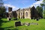 |
| Church of St Oswald | Newton Under Roseberry, Guisborough, Redcar and Cleveland | Church | Earlier than 12th century | 25 April 1984 | NZ5692413255 54°30′41″N 1°07′20″W / 54.511414°N 1.122303°W / 54.511414; -1.122303 (Church of St Oswald) | 1139807 | 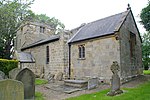 More images |
| Estate Office, Former Joiner's Workshop to West of Home Farmhouse | Guisborough, Redcar and Cleveland | Joiners Shop | Mid 19th century | 16 May 2001 | NZ5952914368 54°31′16″N 1°04′55″W / 54.521117°N 1.081849°W / 54.521117; -1.081849 (Estate Office, Former Joiner's Workshop to West of Home Farmhouse) | 1271502 | 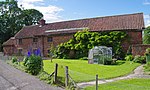 |
| Old Church of St Andrew | Upleatham, Guisborough, Redcar and Cleveland | Church | 12th century | 14 June 1952 | NZ6371219367 54°33′56″N 1°00′58″W / 54.565528°N 1.016156°W / 54.565528; -1.016156 (Old Church of St Andrew) | 1139759 |  |
| Stables, Cart Shed, Granary, Barn and Loose Boxes, to East of Home Farmhouse | Hutton Lowcross, Guisborough, Redcar and Cleveland | Barn | 1826 | 25 April 1984 | NZ5959314354 54°31′16″N 1°04′51″W / 54.520983°N 1.080863°W / 54.520983; -1.080863 (Stables, Cart Shed, Granary, Barn and Loose Boxes, to East of Home Farmhouse) | 1159574 |  |
| Tocketts Mill | Guisborough, Redcar and Cleveland | Watermill | Earlier than c1810 | 30 April 1974 | NZ6269318108 54°33′16″N 1°01′56″W / 54.554342°N 1.032181°W / 54.554342; -1.032181 (Tocketts Mill) | 1329554 |  |
| Church of St Michael | Liverton Village, Loftus, Redcar and Cleveland | Church | 12th century | 20 January 1967 | NZ7111216306 54°32′13″N 0°54′09″W / 54.53704°N 0.90247°W / 54.53704; -0.90247 (Church of St Michael) | 1139676 | 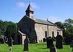 More images |
| Inclined Tramway (lower Building) | Saltburn, Saltburn, Marske and New Marske, Redcar and Cleveland | Engine House | 1884 | 26 February 1999 | NZ6661721707 54°35′10″N 0°58′15″W / 54.58618°N 0.970706°W / 54.58618; -0.970706 (Inclined Tramway (lower Building)) | 1387519 |  |
| Inclined Tramway (upper Building) | Saltburn, Saltburn, Marske and New Marske, Redcar and Cleveland | Incline Keepers Cottage | 1884 | 26 February 1999 | NZ6659721653 54°35′09″N 0°58′16″W / 54.585697°N 0.971028°W / 54.585697; -0.971028 (Inclined Tramway (upper Building)) | 1387523 | 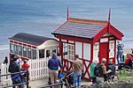 |
Saltburn Pier | Saltburn, Saltburn, Marske and New Marske, Redcar and Cleveland | Pleasure Pier | 1867-1869 | 20 May 1974 | NZ6665621830 54°35′14″N 0°58′12″W / 54.58728°N 0.970075°W / 54.58728; -0.970075 (Saltburn Pier) | 1387526 |  More images |
| War Memorial | Saltburn, Saltburn, Marske and New Marske, Redcar and Cleveland | War Memorial | 1919 | 26 May 1999 | NZ6651221112 54°34′51″N 0°58′21″W / 54.580847°N 0.972465°W / 54.580847; -0.972465 (War Memorial) | 1387499 | 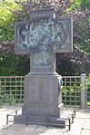 More images |
| Church of All Saints | Skelton, Skelton and Brotton, Redcar and Cleveland | Church | 11th century | 25 May 1966 | NZ6605818994 54°33′43″N 0°58′48″W / 54.561876°N 0.979964°W / 54.561876; -0.979964 (Church of All Saints) | 1250407 |  |
Old Church of All Saints | Skelton, Skelton and Brotton, Redcar and Cleveland | Church | Medieval | 25 May 1966 | NZ6525219038 54°33′45″N 0°59′33″W / 54.562375°N 0.992416°W / 54.562375; -0.992416 (Old Church of All Saints) | 1263246 |  |
| Rushpool Hall | Skelton, Skelton and Brotton, Redcar and Cleveland | Bath House | 1863 | 8 October 1975 | NZ6654420541 54°34′33″N 0°58′20″W / 54.575712°N 0.9721°W / 54.575712; -0.9721 (Rushpool Hall) | 1251344 |  |
| Baptist Church | Redcar and Cleveland | Baptist Chapel | 1905 | 29 April 1988 | NZ5352420781 54°34′46″N 1°10′24″W / 54.579412°N 1.173445°W / 54.579412; -1.173445 (Baptist Church) | 1160408 |  |
| Bastion 100 Metres North West of Kirkleatham Hall Farm | Kirkleatham, Redcar and Cleveland | Bastion | Early 18th century | 23 June 1952 | NZ5943622015 54°35′23″N 1°04′54″W / 54.589841°N 1.081744°W / 54.589841; -1.081744 (Bastion 100 Metres North West of Kirkleatham Hall Farm) | 1160124 |  |
| Bastion and Adjoining Ha Ha Wall 150 Metres North of Kirkleatham Hall Farm | Kirkleatham, Redcar and Cleveland | Ha Ha | Early 18th century | 23 June 1952 | NZ5957022077 54°35′25″N 1°04′47″W / 54.590382°N 1.079658°W / 54.590382; -1.079658 (Bastion and Adjoining Ha Ha Wall 150 Metres North of Kirkleatham Hall Farm) | 1329608 | 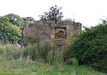 |
| Church of St Cuthbert | Wilton, Redcar and Cleveland | Church | 12th century | 14 June 1952 | NZ5830419745 54°34′10″N 1°05′59″W / 54.569575°N 1.099709°W / 54.569575; -1.099709 (Church of St Cuthbert) | 1310519 |  More images |
| Gatehouse 120 Metres North East of Kirkleatham Hall Farm | Kirkleatham, Redcar and Cleveland | Gatehouse | c. 1780 | 23 June 1952 | NZ5960422006 54°35′23″N 1°04′45″W / 54.58974°N 1.079146°W / 54.58974; -1.079146 (Gatehouse 120 Metres North East of Kirkleatham Hall Farm) | 1160114 |  More images |
| Kirkleatham Hall Farm | Kirkleatham, Redcar and Cleveland | Tack Room | c. 1800 | 23 June 1952 | NZ5952821919 54°35′20″N 1°04′49″W / 54.588967°N 1.08034°W / 54.588967; -1.08034 (Kirkleatham Hall Farm) | 1160085 |  |
| Listening Post 330 Metres of Wheatlands Farmhouse | Redcar and Cleveland | Wall | c. 1916 | 13 May 1986 | NZ6148222954 54°35′53″N 1°03′00″W / 54.598034°N 1.04989°W / 54.598034; -1.04989 (Listening Post 330 Metres of Wheatlands Farmhouse) | 1160275 |  |
| Manor House | Redcar and Cleveland | House | c. 1716 | 22 June 1967 | NZ5447518295 54°33′25″N 1°09′33″W / 54.556971°N 1.159194°W / 54.556971; -1.159194 (Manor House) | 1310999 | 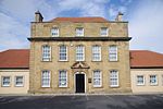 |
| Old Hall Farmhouse and Garden Wall | Lackenby, Redcar and Cleveland | Farmhouse | Mid 17th century | 29 April 1988 | NZ5650319397 54°34′00″N 1°07′39″W / 54.566652°N 1.127628°W / 54.566652; -1.127628 (Old Hall Farmhouse and Garden Wall) | 1139659 |  |
| Old Hall Museum | Kirkleatham, Redcar and Cleveland | School | 18th century | 14 June 1952 | NZ5922321637 54°35′11″N 1°05′06″W / 54.586469°N 1.085116°W / 54.586469; -1.085116 (Old Hall Museum) | 1139641 | 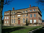 |
| Red Barns House and Red Barns Hotel | Redcar and Cleveland | House | 1868-70 | 29 April 1988 | NZ5966824923 54°36′57″N 1°04′39″W / 54.615944°N 1.077564°W / 54.615944; -1.077564 (Red Barns House and Red Barns Hotel) | 1139613 |  |
| Statue of Justice in Courtyard of Sir William Turners Hospital | Kirkleatham, Redcar and Cleveland | Statue | c. 1720 | 29 April 1988 | NZ5930521580 54°35′09″N 1°05′02″W / 54.585947°N 1.083858°W / 54.585947; -1.083858 (Statue of Justice in Courtyard of Sir William Turners Hospital) | 1310769 | 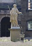 |
| West Lodges with Gates Gatepiers and Flanking Walls | Redcar and Cleveland | Gate | Mid 18th century | 5 May 1952 | NZ5209916911 54°32′41″N 1°11′46″W / 54.544785°N 1.196173°W / 54.544785; -1.196173 (West Lodges with Gates Gatepiers and Flanking Walls) | 1329638 | 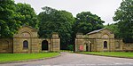 |
Notes
^ The date given is the date used by Historic England as significant for the initial building or that of an important part in the structure's description.
^ Sometimes known as OSGB36, the grid reference is based on the British national grid reference system used by the Ordnance Survey.
^ The "List Entry Number" is a unique number assigned to each listed building and scheduled monument by Historic England.
External links
![]() Media related to Grade II* listed buildings in Redcar and Cleveland at Wikimedia Commons
Media related to Grade II* listed buildings in Redcar and Cleveland at Wikimedia Commons
Grade II* listed buildings in North Yorkshire, Lists of listed buildings in Yorkshire, Redcar and ClevelandUncategorized


