Knapp's Covered Bridge References Navigation menu41°47′9″N 76°33′13″W / 41.78583°N 76.55361°W / 41.78583; -76.5536141°47′9″N 76°33′13″W / 41.78583°N 76.55361°W / 41.78583; -76.55361Covered Bridges of Bradford, Sullivan and Lycoming Counties TR80003428"National Register Information System""National Register of Historic Places Inventory Nomination Form: Covered Bridges of Bradford, Sullivan and Lycoming Counties"eeexpanding iteexpanding ite
Contributing propertyKeeper of the RegisterHistoric districtHistory of the National Register of Historic PlacesNational Park ServiceProperty typesPittsburghLancasterPhiladelphiaCenter CityNorthNortheastNorthwestSouthSouthwestWestAlabamaAlaskaArizonaArkansasCaliforniaColoradoConnecticutDelawareFloridaGeorgiaGuamHawaiiIdahoIllinoisIndianaIowaKansasKentuckyLouisianaMaineMarylandMassachusettsMichiganMinnesotaMississippiMissouriMontanaNebraskaNevadaNew HampshireNew JerseyNew MexicoNew YorkNorth CarolinaNorth DakotaOhioOklahomaOregonPennsylvaniacoveredPuerto RicoRhode IslandSouth CarolinaSouth DakotaTennesseeTexasUtahVermontVirginiaWashingtonWashington, D.C.West VirginiaWisconsinWyoming
Covered bridges on the National Register of Historic Places in PennsylvaniaCovered bridges in PennsylvaniaBridges completed in 1853Wooden bridges in PennsylvaniaBridges in Bradford County, PennsylvaniaRoad bridges in Pennsylvania1853 establishments in PennsylvaniaNational Register of Historic Places in Bradford County, PennsylvaniaRoad bridges on the National Register of Historic Places in PennsylvaniaBurr Truss bridges in the United StatesPennsylvania Registered Historic Place stubsPennsylvania bridge (structure) stubs
Burr arch trusscovered bridgeBurlington TownshipBradford CountyU.S. statePennsylvaniaNational Register of Historic Places
Knapp's Covered Bridge | |
U.S. National Register of Historic Places | |
 | |
 Show map of Pennsylvania  Show map of the United States | |
| Nearest city | Burlington, Pennsylvania |
|---|---|
| Coordinates | 41°47′9″N 76°33′13″W / 41.78583°N 76.55361°W / 41.78583; -76.55361Coordinates: 41°47′9″N 76°33′13″W / 41.78583°N 76.55361°W / 41.78583; -76.55361 |
| Area | 0.1 acres (0.040 ha) |
| Built | 1853 |
| Architectural style | Other, Burr truss |
| MPS | Covered Bridges of Bradford, Sullivan and Lycoming Counties TR |
| NRHP reference # | 80003428[1] |
| Added to NRHP | July 24, 1980 |
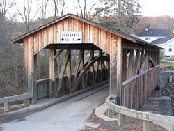
The Knapp's Covered Bridge is a Burr arch truss covered bridge over Brown's Creek in Burlington Township, Bradford County in the U.S. state of Pennsylvania. It was built in 1853 and is 95 feet (29.0 m) long. The bridge was placed on the National Register of Historic Places in 1980, and had a major restoration starting in 2000. Knapp's bridge is named for a local family, and is also known by as the Luther's Mills Covered Bridge (for the nearby village of Luther's Mills) and as the Brown's Creek Covered Bridge.[2][3]
References
^ National Park Service (2010-07-09). "National Register Information System". National Register of Historic Places. National Park Service..mw-parser-output cite.citationfont-style:inherit.mw-parser-output .citation qquotes:"""""""'""'".mw-parser-output .citation .cs1-lock-free abackground:url("//upload.wikimedia.org/wikipedia/commons/thumb/6/65/Lock-green.svg/9px-Lock-green.svg.png")no-repeat;background-position:right .1em center.mw-parser-output .citation .cs1-lock-limited a,.mw-parser-output .citation .cs1-lock-registration abackground:url("//upload.wikimedia.org/wikipedia/commons/thumb/d/d6/Lock-gray-alt-2.svg/9px-Lock-gray-alt-2.svg.png")no-repeat;background-position:right .1em center.mw-parser-output .citation .cs1-lock-subscription abackground:url("//upload.wikimedia.org/wikipedia/commons/thumb/a/aa/Lock-red-alt-2.svg/9px-Lock-red-alt-2.svg.png")no-repeat;background-position:right .1em center.mw-parser-output .cs1-subscription,.mw-parser-output .cs1-registrationcolor:#555.mw-parser-output .cs1-subscription span,.mw-parser-output .cs1-registration spanborder-bottom:1px dotted;cursor:help.mw-parser-output .cs1-ws-icon abackground:url("//upload.wikimedia.org/wikipedia/commons/thumb/4/4c/Wikisource-logo.svg/12px-Wikisource-logo.svg.png")no-repeat;background-position:right .1em center.mw-parser-output code.cs1-codecolor:inherit;background:inherit;border:inherit;padding:inherit.mw-parser-output .cs1-hidden-errordisplay:none;font-size:100%.mw-parser-output .cs1-visible-errorfont-size:100%.mw-parser-output .cs1-maintdisplay:none;color:#33aa33;margin-left:0.3em.mw-parser-output .cs1-subscription,.mw-parser-output .cs1-registration,.mw-parser-output .cs1-formatfont-size:95%.mw-parser-output .cs1-kern-left,.mw-parser-output .cs1-kern-wl-leftpadding-left:0.2em.mw-parser-output .cs1-kern-right,.mw-parser-output .cs1-kern-wl-rightpadding-right:0.2em
^ Zacher, Susan M. and Pennsylvania Historical and Museum Commission. "National Register of Historic Places Inventory Nomination Form: Covered Bridges of Bradford, Sullivan and Lycoming Counties" (PDF). Retrieved 2011-11-17.
^ Evans, Benjamin D.; Evans, June R. (2001). Pennsylvania's Covered Bridges: A Complete Guide (2nd ed.). Pittsburgh, Pennsylvania: University of Pittsburgh Press. pp. 49, 50. ISBN 0-8229-5764-7.
| Wikimedia Commons has media related to Knapp's Covered Bridge. |
US National Register of Historic Places in Pennsylvania | ||
|---|---|---|
| Topics |
|   |
| Lists by county |
| |
| Lists by city |
| |
| Other lists |
| |
| ||
This article about a property in Pennsylvania on the National Register of Historic Places is a stub. You can help Wikipedia by expanding it. |
This article about a bridge in Pennsylvania is a stub. You can help Wikipedia by expanding it. |
1853 establishments in Pennsylvania, Bridges completed in 1853, Bridges in Bradford County, Covered bridges in Pennsylvania, Covered bridges on the National Register of Historic Places in Pennsylvania, National Register of Historic Places in Bradford County, Pennsylvania, Road bridges in Pennsylvania, Road bridges on the National Register of Historic Places in Pennsylvania, Wooden bridges in PennsylvaniaUncategorized


