Namegawa, Saitama Contents Geography Surrounding municipalities History Economy Education Transportation Local attractions External links Navigation menu36°3′57.6″N 139°21′39.5″E / 36.066000°N 139.360972°E / 36.066000; 139.36097236°3′57.6″N 139°21′39.5″E / 36.066000°N 139.360972°E / 36.066000; 139.360972http://www.town.namegawa.saitama.jp/[update]Official Websitee00292924257807802257807802
ChūōIwatsukiKitaMidoriMinamiMinumaNishiŌmiyaSakuraUrawaKasukabeKumagayaChichibu DistrictHigashichichibuMinanoNagatoroOganoYokozeHiki DistrictHatoyamaKawajimaNamegawaOgawaRanzanTokigawaYoshimiIruma DistrictMiyoshiMoroyamaOgoseKitaadachi DistrictInaKitakatsushika DistrictMatsubushiSugitoKodama DistrictKamikawaKamisatoMisatoMinamisaitama DistrictMiyashiroŌsato DistrictYorii
Towns in Saitama PrefectureHiki District, Saitama
townSaitama PrefectureJapanpopulationpopulation densitybedroom community![]() Namegawa, Saitama
Namegawa, Saitama
Namegawa .mw-parser-output .noboldfont-weight:normal 滑川町 | |
|---|---|
Town | |
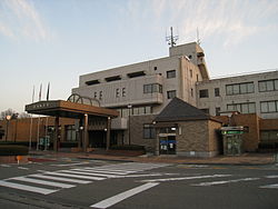 Namegawa town office | |
 Flag  Seal | |
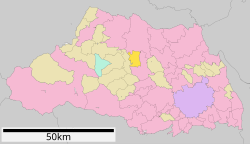 Location of Namegawa in Saitama Prefecture | |
 Namegawa | |
| Coordinates: 36°3′57.6″N 139°21′39.5″E / 36.066000°N 139.360972°E / 36.066000; 139.360972Coordinates: 36°3′57.6″N 139°21′39.5″E / 36.066000°N 139.360972°E / 36.066000; 139.360972 | |
| Country | Japan |
| Region | Kantō |
| Prefecture | Saitama Prefecture |
| District | Hiki |
| Area | |
| • Total | 29.68 km2 (11.46 sq mi) |
| Population (February 2016) | |
| • Total | 18,295 |
| • Density | 616/km2 (1,600/sq mi) |
| Time zone | UTC+9 (Japan Standard Time) |
| - Tree | Pine |
| - Flower | Azalea |
| - Bird | Green pheasant |
| Phone number | 0493-56-2211 |
| Address | 750-1 Fukuda, Namekawa-machi, Hiki-gun, Saitama-ken 355-8585 |
| Website | http://www.town.namegawa.saitama.jp/ |

Musashi Kyūryō National Government Park
Namegawa (滑川町, Namegawa-machi) is a town located in Saitama Prefecture, Japan. As of 1 February 2016[update], the town had an estimated population of 18,294, and a population density of 616 persons per km². Its total area is 29.68 square kilometres (11.46 sq mi).
Contents
1 Geography
2 Surrounding municipalities
3 History
4 Economy
5 Education
6 Transportation
6.1 Railway
6.2 Highway
7 Local attractions
8 External links
Geography
Namekawa is located in a hilly region of central Saitama Prefecture, approximately 60 kilometers from central Tokyo.
Surrounding municipalities
Saitama Prefecture- Kumagaya
- Higshimatsuyama
- Ranzan
History
The village of Namegawa was created on November 3, 1954 by the merger of the villages of Fukuda and Miyamae in Hiki District, Saitama. It was elevated to town status on November 3, 1984. Proposals to merge Namegawa with one or more of its neighbors have been made in 2003, 2004, 2007 and 2008 without success.
Economy
The economy of Namegawa is largely agricultural, although it is also a bedroom community to a significant percentage of the working population, who commute to nearby Saitama City or Tokyo.
Education
Namegawa has three elementary schools, one middle school and one high school.
Transportation
Railway
Tobu Railway – Tobu Tojo Line
Shinrinkōen – Tsukinowa
Highway
- Japan National Route 254
Local attractions
- Musashi Kyūryō National Government Park
External links
![]() Media related to Namegawa, Saitama at Wikimedia Commons
Media related to Namegawa, Saitama at Wikimedia Commons
Official Website (in Japanese)
Saitama (capital) | ||
Wards of Saitama |
| |
| Core cities |
| |
| Special cities |
| |
| Cities |
| |
| Districts |
| |
List of mergers in Saitama Prefecture | ||
Authority control |
|
|---|
Hiki District, Saitama, Towns in Saitama PrefectureUncategorized


